Trail Other activity Lles de Cerdanya - tossa plana de Lles - Photo

tossa plana de Lles

 jopa
jopa

User

© OpenStreetMap contributors
Length
Length
19.3 km
Max alt
Max alt
2903 m
Uphill gradient
Uphill gradient
814 m
Km-Effort
Km-Effort  
32 km
Min alt
Min alt
1469 m
Downhill gradient
Downhill gradient
1462 m
Boucle
Boucle
No
Creation date :
2018-04-16 21:32:57.054
Updated on :
2018-04-16 21:32:57.054

(0 Reviews)

Other activity
Other activity
6h42
Difficulty : Medium

Scan this QR Code to open this trail in the SityTrail application

FREE GPS app for hiking

Logo SityTrail SityTrail

IGN / Geographical institutes

Download SityTrail from the App Store Download SityTrail from Google Play

Logo SityTrail SityTrail World

The world is yours!

Download SityTrail from the App Store Download SityTrail from Google Play Download SityTrail on Huawei AppGallery

About

Trail Other activity of 19.3 km to be discovered at Catalonia, Lleida, Lles de Cerdanya. This trail is proposed by jopa.

Description

Belle montée jusqu'au plus beau point de vue sur la chaîne des Pyrénées ; seul le début est un peu raide dans les cailloux.

Elevation profile

Positioning

Country:
Spain
Region :
Catalonia
Department/Province :
Lleida
Municipality :
Lles de Cerdanya
Location:
Unknown
Start:(UTM)
388551 ; 4699813 (31T) N.

Trails nearby

Trail On foot Lles de Cerdanya - Estanys de la Pera - Photo
On foot
PRO

On foot

Easy
Lles de Cerdanya, Catalonia, Lleida, Spain
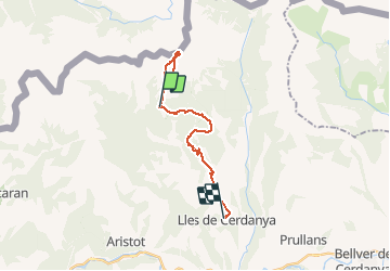
5.4 km | 9.1 km-effort
2h 4min
Yes


Close
My subscriptions